Thimlich Ohinga
|
Rawopaf debak ke Thimlich Ohinga ( englavon Thimlich Ohinga Archaeological Site ), tir burkaf debak ke Kenya. Thimlich Ohinga tir tano katcalapafo izvaxo ke tawava nume bak 2018 wetce arayaf debak ke tamavafa gadakiewega ke UNESCO zo bendeyer.
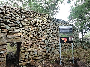
 Tigiso lenttalte Migori widava koe gola ke Victoria Uzda, bato inkexo folkaykirafo kum raporki bak XVI-eafa decemda ape zo vegeduyur. Ohinga anambe va konendara va doda is bonoleem nuzanudayar voxe va koeti is seltskedeem tikis va vuwabolk dere tentuyur. Thimlich Ohinga tir tele loglupafe kruldese is lokiewon nendoyeyene prostewafe anambe. Tir to burkafa tula ke bata prostewa granon vegedusa kum raporki, adalafa gu taneafa vartesa doda ke kuksaxo ke Victoria Uzda is trenayasa mali XVI-eafa decemda kali acku ke XX-eafa decemda. UNESCO : Thimlich Ohinga (en) Situated north-west of the town of Migori, in the Lake Victoria region, this dry-stone walled settlement was probably built in the 16th century CE. The Ohinga (i.e. settlement) seems to have served as a fort for communities and livestock, but also defined social entities and relationships linked to lineage. Thimlich Ohinga is the largest and best preserved of these traditional enclosures. It is an exceptional example of the tradition of massive dry-stone walled enclosures, typical of the first pastoral communities in the Lake Victoria Basin, which persisted from the 16th to the mid-20th century. ~ UNESCO website, licence CC-BY-SA IGO 3.0
Ewava va debak[betara | va krent betá]
Vuestexa[betara | va krent betá]
|
| ||||||||||||||||||||||||||||||||||||||||


