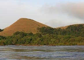
Lopé vedeyaf gerd
|
Lopé vedeyaf gerd ( francavon Parc national de la Lopé ), tir burkaf debak ke Gabona. Lopé vedeyaf gerd tir katcalapafo wetce belcon izvaxo is tuwavaxo nume bak 2007 wetce aotcaf debak ke tamavafa gadakiewega ke UNESCO zo bendeyer.
Tuwavopaf is sentejarayaf patectoy ke Lopé-Okanda vedeyaf gerd va megiltafa walaxa wal izgafa ekamafa bwaala meseitafa is sentejafa meilafa anameda bravasa va ruelgapa dem irubaxo is katca don moukdunolap rekeon griawis atoer. Va tuwavopafa is bliopafa abduaxa ke zalera ke katca is irubaxo nope direoprugalafa lidawickarura divnedir. Bata belca lospasa va debak evlon gu Lekeraporugal is Azilugal is dem strabrega ke lekeraporugalafa yamba tir tcaza ke lamasa lyapa moolaniyina gan Bantu saneik is aryone sane vey taltefa Afrika kenolaniyise va Ogooué krant valent ekamafo aalxo ke Kongoa is ist tadava isu varon isu vage. Bat lamas rust va vonera ke kota geesaxarafa Afrika al asketcad. UNESCO : Lopé vedeyaf gerd (en) The Ecosystem and Relict Cultural Landscape of Lopé-Okanda demonstrates an unusual interface between dense and well-conserved tropical rainforest and relict savannah environments with a great diversity of species, including endangered large mammals, and habitats. The site illustrates ecological and biological processes in terms of species and habitat adaptation to post-glacial climatic changes. It contains evidence of the successive passages of different peoples who have left extensive and comparatively well-preserved remains of habitation around hilltops, caves and shelters, evidence of iron-working and a remarkable collection of some 1,800 petroglyphs (rock carvings). The property’s collection of Neolithic and Iron Age sites, together with the rock art found there, reflects a major migration route of Bantu and other peoples from West Africa along the River Ogooué valley to the north of the dense evergreen Congo forests and to central east and southern Africa, that has shaped the development of the whole of sub-Saharan Africa. ~ UNESCO website, licence CC-BY-SA IGO 3.0
Ewava va debak[betara | va krent betá]
Vuestexa[betara | va krent betá]
|
| |||||||||||||||||||||||||||||||||||||


