
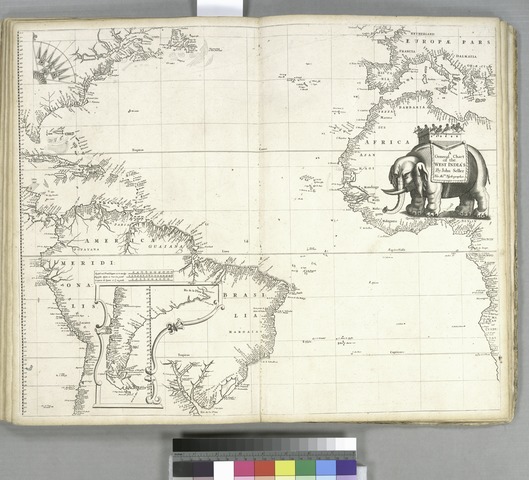
Iyeltak:A general chart of the West India's (sic) - by John Seller, His Maties. hydrographer. NYPL433733.tiff

Taille de cet aperçu JPG pour ce fichier TIF : 660 × 599 px. Ar goraks: 264 × 240 px | 529 × 480 px | 846 × 768 px | 1128 × 1024 px | 2255 × 2048 px | 4655 × 4227 px.
Xantaf iyeltak (4655 × 4227 pixel, iyeltakaldo : 56,3 Mio, MIME ord : image/tiff)
Pimtara
| Pimtara | A general chart of the West India's [sic] / by John Seller, His Maties. hydrographer.; Lawrence H. Slaughter Collection of English maps, charts, globes, books and atlases / Atlases / Atlas maritimus, or, The sea-atlas : being a book of maritime charts describing the sea-coasts, capes, headlands, sands, shoals, rocks, and dangers, the bays, roads, harbors, rivers and ports, in most of the known parts of the world : collected from the latest and best discoveries that have been made by divers able and experienced navigators of our English nation : accommodated with a hydrographical description of the whole world, shewing the chief cities, towns, and places of trade and commerce, with the nature of the commodities and merchandizes of each country, very useful for merchants and all other persons concerned in maritime affairs / by John Seller, hydrographer to the King. | |||||||||||||||||||||||
| Notes | Covers the Atlantic Ocean, adjacent coastlines, the western Mediterranean, and the Pacific coast of South America. ''Note 2.'') Includes inset of southern South America and decorative cartouche with elephant ill. ''Note 3.'') Lawrence H. Slaughter Collection ; 440. ''Note 4.'') NYPL copy includes annotations in ink between the coast of Europe and the coast of South America. | |||||||||||||||||||||||
| Catalogue call number | Map Div. 97-6040 ([map 16]) [In LHS 315] | |||||||||||||||||||||||
| Standard reference | Phillips 487; Phillips 4154 | |||||||||||||||||||||||
| Evla | ||||||||||||||||||||||||
| Klita |
http://digitalgallery.nypl.org/nypldigital/dgkeysearchdetail.cfm?imageID=433733
|
|||||||||||||||||||||||
| Askisik | Darby, John, 1624 or 5-1704 -- Printer; Seller, John, fl. 1658-1698 -- Cartographer | |||||||||||||||||||||||
| Novera (Va bata ewava gin faver) |
From The Lionel Pincus and Princess Firyal Map Division. http://maps.nypl.org
|
|||||||||||||||||||||||
| Source description | 1 atlas ([2], 4 p., [40] leaves of plates) : 20 maps ; 45 cm. | |||||||||||||||||||||||
| Location | Stephen A. Schwarzman Building / The Lionel Pincus and Princess Firyal Map Division | |||||||||||||||||||||||
| Digital item published | 2-3-2004; updated 1-9-2012 | |||||||||||||||||||||||
| Digital ID | 433733 | |||||||||||||||||||||||

Этот документ был создан при поддержке Викимедиа Великобритания.
Чтобы ознакомиться с другими файлами, созданными при поддержке этой организации, посетите, пожалуйста, категорию При поддержке Викимедиа Великобритания.
|
Iyeltakizvot
Witison va iyeltak inde in banugale awir, va evla/bartiv vulegal !!
| Evla/Bartiv | Aluk | Lumeem | Favesik | Sebuks | |
|---|---|---|---|---|---|
| ref | 20 balemeaksat 2014 à 08:41 |  | 4655 × 4227 (56,3 Mio) | Fæ | GWToolset:: Creating mediafile for Fæ. Tranche 2.389 |
Favera va iyeltak
Valevefa bugluyaxa va bat iyeltak :