
Iyeltak:Pula Aerial View.jpg

Lum ke bata abdiwira : 800 × 488 px. Ar goraks: 320 × 195 px | 640 × 390 px | 1024 × 625 px | 1495 × 912 px.
Xantaf iyeltak (1495 × 912 pixel, iyeltakaldo : 1,01 Mio, MIME ord : image/jpeg)

|
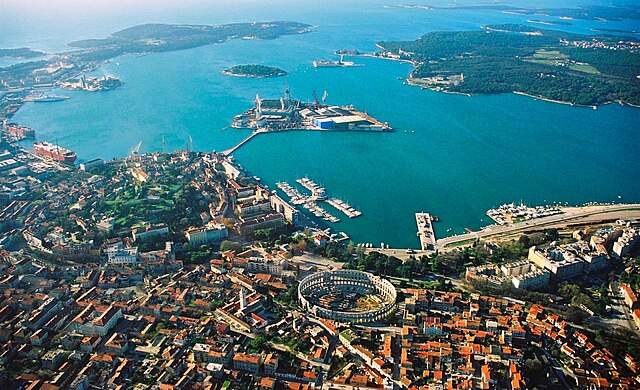
Cette image a été promue selon les critères des images de valeur, et est considérée comme l’image de plus grande valeur sur Commons dans le domaine : Pula, Croatia. La proposition est consultable sur Commons:Valued image candidates/Pula Croatia2. |
| Pimtara |
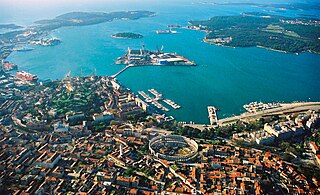
English: Aerial view of Pula, Croatia. The most notable object, on the bottom of the photo, is the Arena Amphiteathre. Left of it is the hill around which lies the Old Town. The wedge-shaped island in the middle of the bay is Uljanik, part of the shipyard. On the far top right the Brijuni islands (a National Park) can be seen.
Русский: Вид с высоты птичьего полета на Пулу (Хорватия). Самый примечательный объект, расположенный в нижней части фотографии, это амфитеатр Пулы. Слева от него находится холм, вокруг которого раскинулся Старый город. Клиновидный остров посреди бухты - это Uljanik, часть верфи. В дальнем правом верхнем углу видны острова Бриони (национальный парк). |
||||||||
| Evla | 02:57, 19 ago 2007 (dati Exif) | ||||||||
| Klita |
self-made, better version than |
||||||||
| Askisik | Orlovic | ||||||||
| Novera (Va bata ewava gin faver) |
|
| Lieu de la prise de vue | | Voir cet endroit et d’autres images sur : OpenStreetMap |
|---|
Notes
- I uploaded it also on Panoramio, but only after doing it on commons --Orlovic 21:40, 5 February 2007 (UTC)

|
Permission is granted to copy, distribute and/or modify this document under the terms of the GNU Free Documentation License, Version 1.2 or any later version published by the Free Software Foundation; with no Invariant Sections, no Front-Cover Texts, and no Back-Cover Texts. A copy of the license is included in the section entitled GNU Free Documentation License. |
| Bat iyeltak wetce Creative Commons Attribution-Share Alike 3.0 Unported zo sortayar. | ||
| ||
| Ce bandeau de licence a été ajouté à ce fichier dans le cadre de la procédure de mise à jour des licences des images sous GFDL. |
| Annotations | This image is annotated: View the annotations at Commons |
Iyeltakizvot
Witison va iyeltak inde in banugale awir, va evla/bartiv vulegal !!
| Evla/Bartiv | Aluk | Lumeem | Favesik | Sebuks | |
|---|---|---|---|---|---|
| ref | 19 anyusteaksat 2007 à 01:06 | | 1495 × 912 (1,01 Mio) | Orlovic | {{Information |Description=Aerial view of Pula, Croatia |Source= My friend gave me the photo to publish under GFDL, better version than 50px |Date= |Author= Darko D. |permission={{GFDL}} }} == Notes == *I uploaded it also on [htt |
| 19 anyusteaksat 2007 à 01:01 |  | 1495 × 1000 (1,68 Mio) | Orlovic | {{Information |Description=Aerial view of Pula, Croatia |Source= My friend gave me the photo to publish under GFDL, better version than 50px |Date= |Author= Darko D. |permission={{GFDL}} }} == Notes == *I uploaded it also on [htt |
Favera va iyeltak
Valevefa bugluyaxa va bat iyeltak :
Jadifa iyeltakura
Valevefi wiki va bat iyeltak malsaved :
- Favera dene af.wikipedia.org
- Favera dene ar.wikipedia.org
- Favera dene arz.wikipedia.org
- Favera dene az.wikipedia.org
- Favera dene ba.wikipedia.org
- Favera dene be-tarask.wikipedia.org
- Favera dene be.wikipedia.org
- Favera dene bg.wikipedia.org
- Favera dene bs.wikipedia.org
- Favera dene ca.wikipedia.org
- Favera dene ceb.wikipedia.org
- Favera dene cs.wikipedia.org
- Favera dene cy.wikipedia.org
- Favera dene da.wikipedia.org
- Favera dene de.wikipedia.org
- Favera dene de.wikivoyage.org
- Favera dene el.wikipedia.org
- Favera dene en.wikipedia.org
- Favera dene en.wikivoyage.org
- Favera dene eo.wikipedia.org
loa favera va bat iyeltak wil !!