
Iyeltak:Morocco Topography.png

Lum ke bata abdiwira : 687 × 600 px. Ar goraks: 275 × 240 px | 550 × 480 px | 880 × 768 px | 1173 × 1024 px | 1774 × 1549 px.
Xantaf iyeltak (1774 × 1549 pixel, iyeltakaldo : 2,74 Mio, MIME ord : image/png)
Pimtara
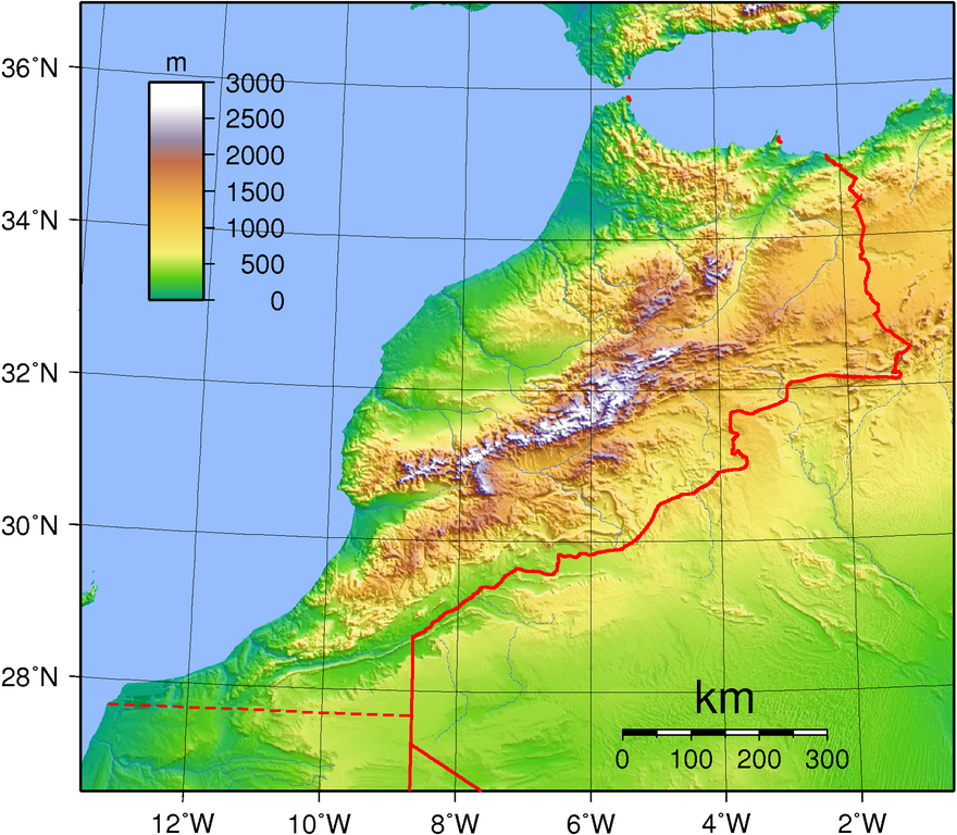
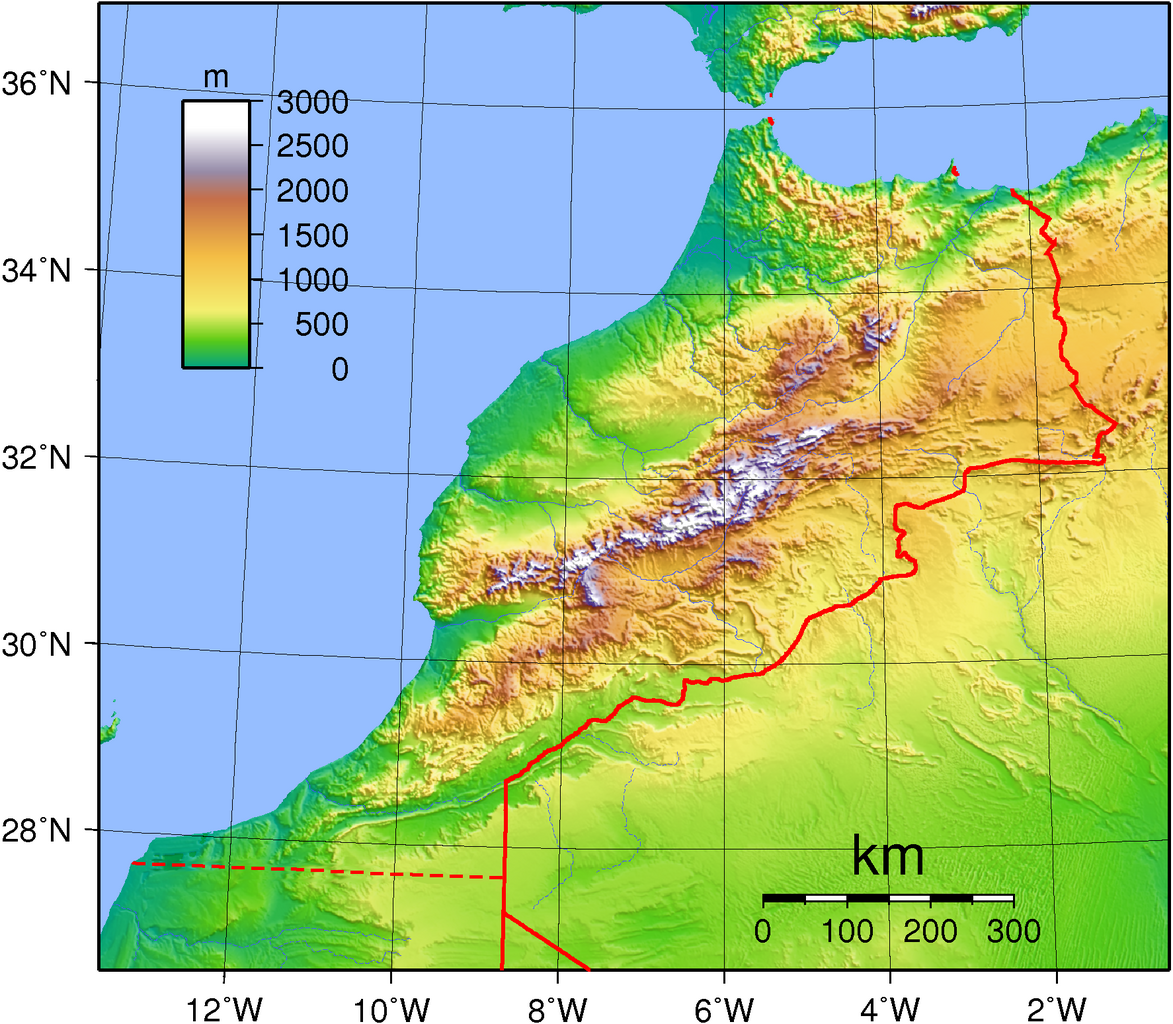
| Pimtara | Topographic map of Morocco. Created with GMT from publicly available GLOBE data. |
| Evla | |
| Klita | Pilkaf grabom |
| Askisik | Sadalmelik |
Sortara :
| Cette œuvre a été placée dans le domaine public par son auteur, I, Sadalmelik. Ceci s’applique dans le monde entier. Dans certains pays, ceci peut ne pas être possible ; dans ce cas : I, Sadalmelik accorde à toute personne le droit d’utiliser cette œuvre dans n’importe quel but, sans aucune condition, sauf celles requises par la loi. |
Iyeltakizvot
Witison va iyeltak inde in banugale awir, va evla/bartiv vulegal !!
| Evla/Bartiv | Aluk | Lumeem | Favesik | Sebuks | |
|---|---|---|---|---|---|
| ref | 22 santaneaksat 2020 à 07:32 | | 1774 × 1549 (2,74 Mio) | Christian Ferrer | it seems that is was within this version since a long time |
| 21 santaneaksat 2020 à 19:15 |  | 1774 × 1549 (1,92 Mio) | Christian Ferrer | Reverted to version as of 18:52, 21 November 2020 (UTC) | |
| 21 santaneaksat 2020 à 18:56 |  | 1774 × 1549 (1,91 Mio) | Taha Khattabi | Reverted to version as of 18:41, 21 November 2020 (UTC) | |
| 21 santaneaksat 2020 à 18:52 |  | 1774 × 1549 (1,92 Mio) | M.Bitton | Reverted to version as of 18:20, 21 November 2020 (UTC) | |
| 21 santaneaksat 2020 à 18:41 |  | 1774 × 1549 (1,91 Mio) | Taha Khattabi | Reverted to version as of 06:53, 21 November 2020 (UTC) | |
| 21 santaneaksat 2020 à 18:20 |  | 1774 × 1549 (1,92 Mio) | M.Bitton | Reverted to version as of 07:43, 11 September 2013 (UTC) | |
| 21 santaneaksat 2020 à 06:53 |  | 1774 × 1549 (1,91 Mio) | Taha Khattabi | There is no present border at that location, only the Berm Wall which is located south of this | |
| 21 santaneaksat 2020 à 06:52 |  | 1774 × 1549 (2,74 Mio) | Taha Khattabi | Reverted to version as of 12:49, 27 December 2013 (UTC) | |
| 21 santaneaksat 2020 à 06:39 |  | 1774 × 1549 (1,91 Mio) | Taha Khattabi | There is no present border at that location, only the Berm Wall which is located south of this | |
| 27 santoleaksat 2013 à 12:49 |  | 1774 × 1549 (2,74 Mio) | Omar-toons | dotted line for disputed border |
Favera va iyeltak
Valevefa bugluyaxa va bat iyeltak :
Jadifa iyeltakura
Valevefi wiki va bat iyeltak malsaved :
- Favera dene af.wikipedia.org
- Favera dene ar.wikipedia.org
- Favera dene ast.wikipedia.org
- Favera dene bg.wikipedia.org
- Favera dene bn.wikipedia.org
- Favera dene br.wikipedia.org
- Favera dene ca.wikipedia.org
- Favera dene da.wikipedia.org
- Favera dene de.wikipedia.org
- Favera dene el.wikipedia.org
- Favera dene en.wikipedia.org
- Favera dene es.wikipedia.org
- Favera dene fa.wikipedia.org
- Favera dene fi.wikipedia.org
- Favera dene fr.wikipedia.org
- Favera dene hu.wikipedia.org
- Favera dene id.wikipedia.org
- Favera dene ig.wikipedia.org
- Favera dene io.wikipedia.org
- Favera dene it.wikipedia.org
- Favera dene lt.wikipedia.org
- Favera dene ms.wikipedia.org
- Favera dene pl.wikipedia.org
- Favera dene ro.wikipedia.org
- Favera dene ru.wikipedia.org
- Favera dene ru.wikimedia.org
- Favera dene sr.wikipedia.org
- Favera dene tr.wikipedia.org
- Favera dene uk.wikipedia.org
- Favera dene vec.wikipedia.org
- Favera dene vep.wikipedia.org