
Iyeltak:Civitas Londinium or The Agas Map of London.jpg

Lum ke bata abdiwira : 800 × 338 px. Ar goraks: 320 × 135 px | 640 × 271 px | 1024 × 433 px | 1280 × 541 px | 4730 × 2000 px.
Xantaf iyeltak (4730 × 2000 pixel, iyeltakaldo : 4,08 Mio, MIME ord : image/jpeg)
Pimtara
| Pimtara |
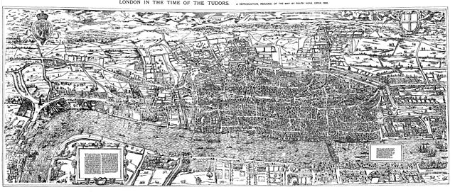
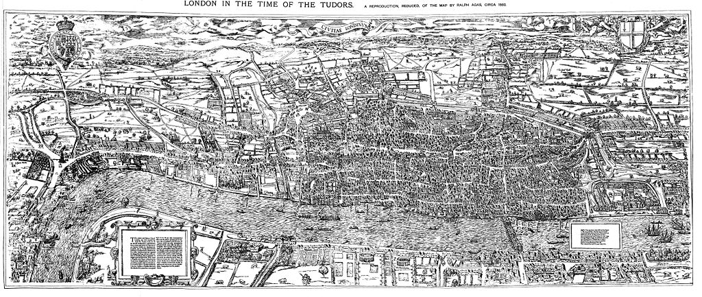
English: The earliest proper map (as opposed to panorama) of London known. Attributed to Ralph Agas, and probably surveyed between 1570 and 1605. The original was 6 foot 0.5 inches long by 2 feet 4.5 inches wide. This much reduced image is a scan of a copy of a lithograph of a copy, was itself badly repaired with sellotape and has had to be "restored"; so is hardly a truly faithful representation of the original, but few good copies exist and no other detailed public domain images are known. |
| Evla | |
| Klita | Maps of Old London, London, Adam and Charles Black, 1908. Scanned & corrected Mike Calder. |
| Askisik | Mike Calder, image of Civitas Londinium, Agas' Map of London, c. 1570-1605 |
| Autres versions | Derivative works of this file: Covent Garden from the Ralph Agas 1572 map of London.jpg |
Sortara :
|
Cette œuvre est également dans le domaine public dans tous les pays pour lesquels le droit d’auteur a une durée de vie de 100 ans ou moins après la mort de l’auteur. | |
| Ce fichier a été identifié comme étant exempt de restrictions connues liées au droit d’auteur, y compris tous les droits connexes et voisins. | |
Iyeltakizvot
Witison va iyeltak inde in banugale awir, va evla/bartiv vulegal !!
| Evla/Bartiv | Aluk | Lumeem | Favesik | Sebuks | |
|---|---|---|---|---|---|
| ref | 14 anyusteaksat 2009 à 18:59 | | 4730 × 2000 (4,08 Mio) | MikeCalder | {{Information |Description={{en|1=The earliest proper map (as opposed to panorama) of London known. Attributed to Ralph Agas, and probably surveyed between 1570 and 1605. The original was 6 foot 0.5 inches long by 2 feet 4.5 inches wide. This much reduc |
Favera va iyeltak
Valevefa bugluyaxa va bat iyeltak :
Jadifa iyeltakura
Valevefi wiki va bat iyeltak malsaved :
- Favera dene af.wikipedia.org
- Favera dene ar.wikipedia.org
- Favera dene azb.wikipedia.org
- Favera dene de.wikipedia.org
- Favera dene el.wikipedia.org
- Favera dene en.wikipedia.org
- Favera dene es.wikipedia.org
- Favera dene fa.wikipedia.org
- Favera dene hy.wikipedia.org
- Favera dene it.wikipedia.org
- Favera dene ja.wikipedia.org
- Favera dene ko.wikipedia.org
- Favera dene la.wikipedia.org
- Favera dene pt.wikipedia.org
- Favera dene ro.wikipedia.org
- Favera dene ru.wikipedia.org
- Favera dene simple.wikipedia.org
- Favera dene sl.wikipedia.org
- Favera dene tr.wikipedia.org
- Favera dene uk.wikipedia.org
- Favera dene zh.wikipedia.org