
Iyeltak:Caribbean Sea Gulf of Mexico shaded relief bathymetry land map.png
Xantaf iyeltak (1024 × 664 pixel, iyeltakaldo : 1,1 Mio, MIME ord : image/png)
Pimtara
| Pimtara |
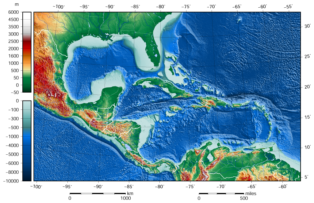
English: The shaded relief bathymetry and land map of the Caribbean Sea and Gulf of Mexico area. The map was created using the Generic Mapping Tools, GMT, version 5.1.1. |
| Evla | |
| Klita |
Travail personnel avec: the following Public Domain datasets for the relief:
|
| Askisik | Darekk2 using the ETOPO1 and GLOBE tiles |
| Autres versions |
The same image but contoured at -100 m: |

Sortara :
Attribution (in addition to the author of this map):
The NGDC in it's copyright notice says:
As required by 17 U.S.C. 403, third parties producing copyrighted works consisting predominantly of the material produced by U.S. government agencies must provide notice with such work(s) identifying the U.S. Government material incorporated and stating that such material is not subject to copyright protection within the United States. (...)
(for credits see the Source section).
and GLOBE and ETOPO1
(see above and the Source section)
- Til nuyaf :
- Ta walzilira – ta ksudara va kobara azu walzilira azu deara
- Ta warzafa ponara – Ta zalera va grabom
- Nope valevef kredeem :
- gaara – Va folack govanzilil ise va gluyaxa godaful ise gobazel kase betara al zo skud. Laninde gonaskil voxe mekane gometiavel da gelfasik va rin ik rinafa favera vanovar.
- Milinde paká – Ede va bat valdig betal ike artazukar ike voner, pune va nekis valdig wetce mila ok milafa sorta gu bat goxolel.
Iyeltakizvot
Witison va iyeltak inde in banugale awir, va evla/bartiv vulegal !!
| Evla/Bartiv | Aluk | Lumeem | Favesik | Sebuks | |
|---|---|---|---|---|---|
| ref | 8 teveaksat 2015 à 09:58 | | 1024 × 664 (1,1 Mio) | Darekk2 | added lakes ... and changed palette for land (white highest mountains) |
| 12 alubeaksat 2015 à 15:23 |  | 1024 × 664 (1,09 Mio) | Darekk2 | changed the illumination azimuth from 100 to 45 deg. | |
| 21 bareaksat 2015 à 15:59 |  | 1024 × 664 (1,11 Mio) | Darekk2 | a little wider in the east | |
| 21 bareaksat 2015 à 15:07 |  | 1024 × 664 (1,11 Mio) | Darekk2 | changed parallels of the projection, removed black borderline | |
| 19 bareaksat 2015 à 15:05 |  | 1024 × 684 (1,15 Mio) | Darekk2 | shortened elevation and depth legends | |
| 18 bareaksat 2015 à 18:25 |  | 1024 × 684 (1,15 Mio) | Darekk2 | User created page with UploadWizard |
Favera va iyeltak
Valevefa bugluyaxa va bat iyeltak :
Jadifa iyeltakura
Valevefi wiki va bat iyeltak malsaved :
- Favera dene ar.wikipedia.org
- Favera dene en.wikipedia.org
- Favera dene gl.wikipedia.org
- Favera dene hr.wikipedia.org
- Favera dene sd.wikipedia.org
- Favera dene sr.wikipedia.org
- Favera dene vep.wikipedia.org