
Iyeltak:Zakarid Armenia 1200 map-fr.svg

Taille de cet aperçu PNG pour ce fichier SVG : 800 × 470 px. Ar goraks: 320 × 188 px | 640 × 376 px | 1024 × 601 px | 1280 × 751 px | 2560 × 1503 px | 2717 × 1595 px.
Xantaf iyeltak (SVG iyeltak, prekson 2717 × 1595 pixels, iyeltakaldo : 686 kio)
Pimtara
| Pimtara |
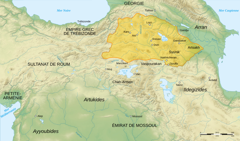
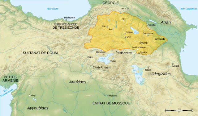
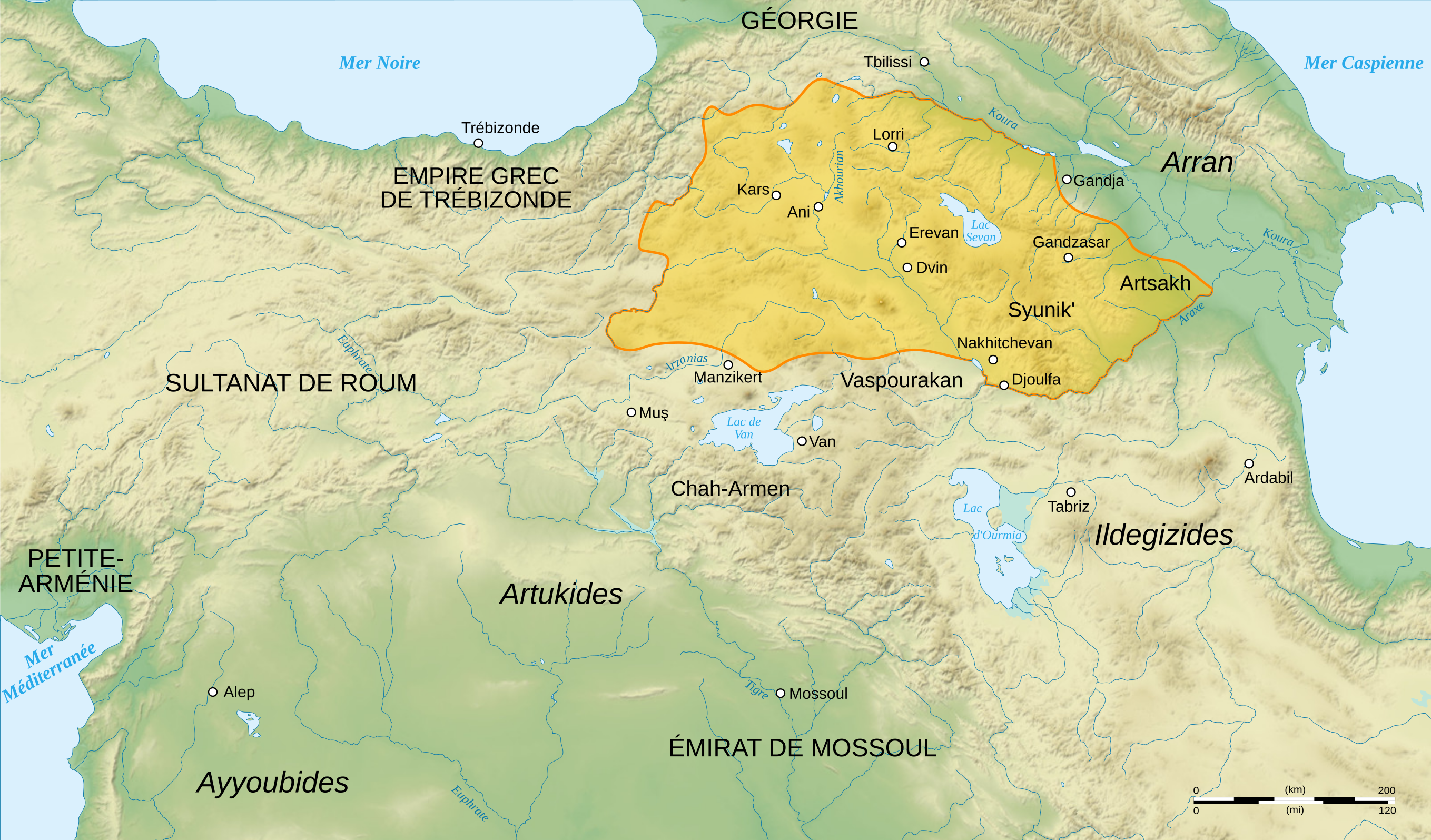
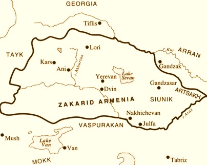
English: French map of Zakarid Armenia, around the year 1200 AD. (Source: George A. Bournoutian - «A Concise History of the Armenian People», map 19. Mazda Publishers, Inc. Costa Mesa California 2006)
Français : Carte en français de l'Arménie zakaride, vers l'an mille. |
||
| Evla | |||
| Klita |
Pilkaf grabom. Sources :
Logiciels utilisés :
Autres données :
|
||
| Askisik | Sémhur | ||
| Autres versions | |||
| Gaara (imposé par la licence) | © Sémhur / Wikimedia Commons / | ||
| SVG | W3C-validity not checked. Cette image vectorielle non W3C-spécifiée a été créée avec Inkscape .
|
||
| Graphic Lab |

| Lieu de la prise de vue | | Voir cet endroit et d’autres images sur : OpenStreetMap |
|---|
Sortara :
Moi, en tant que détenteur des droits d’auteur sur cette œuvre, je la publie sous les licences suivantes :
| Copyleft : cette œuvre d’art est libre ; vous pouvez la redistribuer ou la modifier selon les termes de la licence Art Libre. Vous trouverez un exemplaire de cette licence sur le site Copyleft Attitude ainsi que sur d’autres sites. |
This file is licensed under the Creative Commons Attribution-Share Alike 4.0 International, 3.0 Unported, 2.5 Generic, 2.0 Generic and 1.0 Generic license.
- Til nuyaf :
- Ta walzilira – ta ksudara va kobara azu walzilira azu deara
- Ta warzafa ponara – Ta zalera va grabom
- Nope valevef kredeem :
- gaara – Va folack govanzilil ise va gluyaxa godaful ise gobazel kase betara al zo skud. Laninde gonaskil voxe mekane gometiavel da gelfasik va rin ik rinafa favera vanovar.
- Milinde paká – Ede va bat valdig betal ike artazukar ike voner, pune va nekis valdig wetce mila ok milafa sorta gu bat goxolel.
Va solnarina sorta rorewal
Iyeltakizvot
Witison va iyeltak inde in banugale awir, va evla/bartiv vulegal !!
| Evla/Bartiv | Aluk | Lumeem | Favesik | Sebuks | |
|---|---|---|---|---|---|
| ref | 20 santoleaksat 2015 à 00:24 | | 2717 × 1595 (686 kio) | Geagea | Reverted to version as of 18:22, 3 August 2008 (UTC). Please upload the file with a new filename. Also see COM:OVERWRITE |
| 19 santoleaksat 2015 à 16:48 |  | 2717 × 1595 (640 kio) | Ercwlff | Zakarid Armenia was not an independent kingdom and it had to be shown here | |
| 18 santoleaksat 2015 à 16:19 |  | 2717 × 1595 (686 kio) | Denniss | Reverted to version as of 18:22, 3 August 2008 (UTC) - map is tagged/named as having french language, please upload under new name | |
| 18 santoleaksat 2015 à 14:55 |  | 2717 × 1595 (728 kio) | Georgiano | translated into English. it's looks more historically accurate now | |
| 3 anyusteaksat 2008 à 18:22 |  | 2717 × 1595 (686 kio) | Sémhur | Typography | |
| 3 anyusteaksat 2008 à 16:19 |  | 2717 × 1595 (687 kio) | Sémhur | == Description == {{Information |Description= {{en| French map of Zakarid Armenia, around the year 1200 AD.}} {{fr| Carte en français de l'Arménie zakaride, vers l'an mille.}} |Source=Travail personnel. Sources : * Fond de carte : [http://www2.jpl.nasa. |
Favera va iyeltak
Valevefa bugluyaxa va bat iyeltak :
Jadifa iyeltakura
Valevefi wiki va bat iyeltak malsaved :
- Favera dene azb.wikipedia.org
- Favera dene ca.wikipedia.org
- Favera dene cs.wikipedia.org
- Favera dene el.wikipedia.org
- Favera dene en.wikipedia.org
- Favera dene eo.wikipedia.org
- Favera dene fa.wikipedia.org
- Favera dene fr.wikipedia.org
- Noravank
- Horomos
- Chronologie de l'Arménie
- Wikipédia:Lumière sur/Mars 2009
- Mkhargrdzéli-Zachariades
- Wikipédia:Atelier graphique/Cartes/Archives/août 2008
- Arménie zakaride
- Wikipédia:Sélection/Arménie
- Wikipédia:Lumière sur/Arménie zakaride
- Miniature arménienne
- Wikipédia:Sélection/Géorgie (pays)
- Portail:Asie/Lumière sur…/Bons articles
- Wikipédia:Lumière sur/Avril 2022
- Favera dene hr.wikipedia.org
- Favera dene hy.wikipedia.org
- Favera dene hyw.wikipedia.org
- Favera dene it.wikipedia.org
- Favera dene ka.wikipedia.org
- Favera dene ko.wikipedia.org
- Favera dene nl.wikipedia.org
- Favera dene ru.wikipedia.org
loa favera va bat iyeltak wil !!