
Iyeltak:Serval range IUCN.svg

Taille de cet aperçu PNG pour ce fichier SVG : 635 × 600 px. Ar goraks: 254 × 240 px | 508 × 480 px | 813 × 768 px | 1084 × 1024 px | 2169 × 2048 px | 1525 × 1440 px.
Xantaf iyeltak (SVG iyeltak, prekson 1525 × 1440 pixels, iyeltakaldo : 706 kio)
Pimtara
| Pimtara |
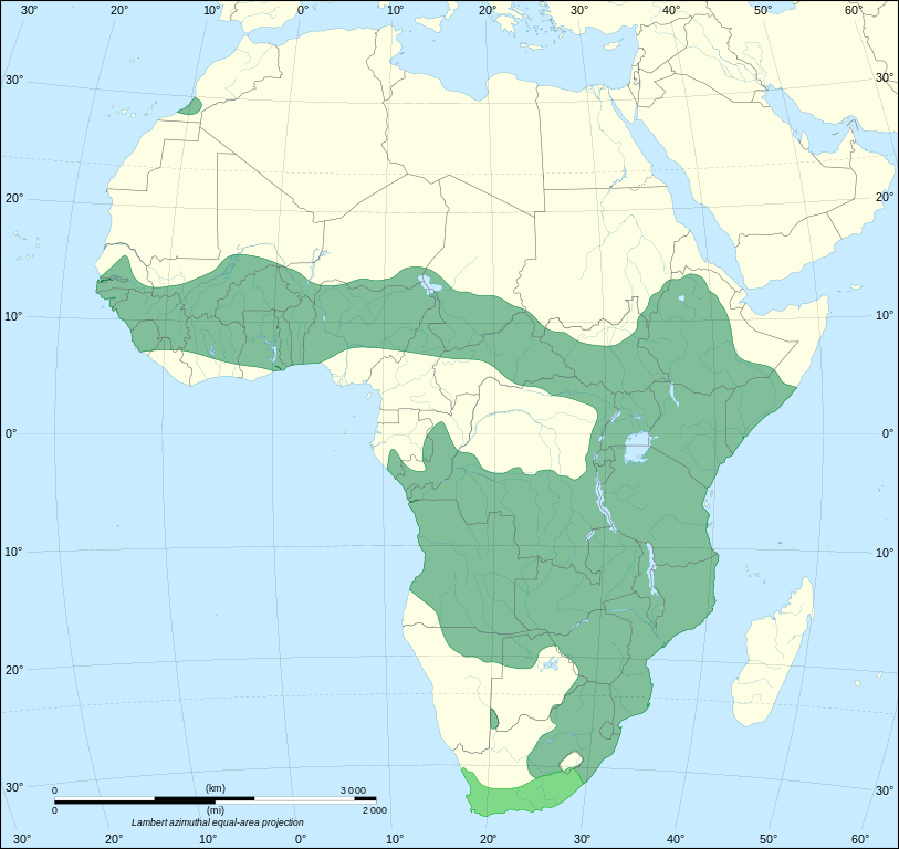
The range of Leptailurus serval, based on version sourced from IUCN Red List. |
| Evla | (UTC) |
| Klita |
Ce fichier est dérivé de : |
| Askisik |
|

| Cette image a été retouchée, ce qui signifie qu'elle a été modifiée par ordinateur et est différente de l'image d'origine. Liste des modifications : Redrawn as SVG on better Africa blank. L'image d'origine se trouve ici : Africa map blank.svg:
|
Sortara :
Bat iyeltak wetce Creative Commons Attribution-Share Alike 3.0 Unported zo sortayar.
- Til nuyaf :
- Ta walzilira – ta ksudara va kobara azu walzilira azu deara
- Ta warzafa ponara – Ta zalera va grabom
- Nope valevef kredeem :
- gaara – Va folack govanzilil ise va gluyaxa godaful ise gobazel kase betara al zo skud. Laninde gonaskil voxe mekane gometiavel da gelfasik va rin ik rinafa favera vanovar.
- Milinde paká – Ede va bat valdig betal ike artazukar ike voner, pune va nekis valdig wetce mila ok milafa sorta gu bat goxolel.
Journal des téléversements d’origine
This image is a derivative work of the following images:
- File:Serval_range.png licensed with Cc-by-sa-2.5,2.0,1.0, Cc-by-sa-3.0-migrated, GFDL
- 2012-02-28T21:17:32Z Izvora 606x649 (28279 Bytes) Source http://maps.iucnredlist.org/map.html?id=11638
- 2011-12-27T11:18:12Z Schneelocke 907x955 (40507 Bytes) New map is unusable for colorblind readers. See talk page.
- 2011-07-19T02:07:48Z Craig Pemberton 344x372 (14385 Bytes) Normalize with other range maps in preparation for composite maps of higher taxa.
- 2005-12-09T22:49:27Z Laurascudder 907x955 (40507 Bytes) The range of [[leptailurus serval]]. Started from [[w: User:Brion VIBBER/Maps and images for Wikipedia|Brion VIBBER]]'s maps using information from [http://wildcat.cat-city.com/serval/map-serv.gif], [http://www.wildcatconser
- File:Africa_map_blank.svg licensed with Cc-by-sa-2.5,2.0,1.0, Cc-by-sa-3.0-migrated, GFDL
- 2011-07-14T19:50:24Z Sting 1525x1440 (698781 Bytes) Sudan/South Sudan 2011-07 border update
- 2009-01-10T20:36:44Z Sting 1525x1440 (710059 Bytes) Detail correction
- 2008-06-27T03:34:58Z Sting 1525x1440 (711453 Bytes) Completely new drawing with known projection
- 2006-05-31T15:28:42Z Sting 1390x1295 (571519 Bytes) Enhanced version : African and Asian continents separated
- 2006-05-31T03:53:32Z Sting 1390x1295 (566642 Bytes) {{Information |Description=Blank vector graphic map of [[:Category:Maps of Africa|Africa]] |Source=Several bitmap-type maps |Date= May 2006 |Author= Eric Gaba ([[User:Sting|Sting]]) |Permission=GFDL or CC-BY-SA |other_version
Téléversé avec derivativeFX
Iyeltakizvot
Witison va iyeltak inde in banugale awir, va evla/bartiv vulegal !!
| Evla/Bartiv | Aluk | Lumeem | Favesik | Sebuks | |
|---|---|---|---|---|---|
| ref | 21 saneaksat 2012 à 02:36 | | 1525 × 1440 (706 kio) | Odysseus1479 | == {{int:filedesc}} == {{Information |Description=The range of ''Leptailurus serval'', based on version sourced from [http://maps.iucnredlist.org/map.html?id=11638 IUCN Red List].<br> Darker green: extant (resident). Brighter green: extinct. |Sourc... |
Favera va iyeltak
Valevefa bugluyaxa va bat iyeltak :
Jadifa iyeltakura
Valevefi wiki va bat iyeltak malsaved :
- Favera dene en.wikipedia.org
- Favera dene fr.wikipedia.org
- Favera dene it.wikipedia.org
- Favera dene kg.wikipedia.org
- Favera dene kk.wikipedia.org
- Favera dene ko.wikipedia.org
- Favera dene lv.wikipedia.org
- Favera dene mk.wikipedia.org
- Favera dene sq.wikipedia.org
- Favera dene th.wikipedia.org
- Favera dene tl.wikipedia.org
- Favera dene tr.wikipedia.org
- Favera dene uk.wikipedia.org
- Favera dene vi.wikipedia.org