
Iyeltak:New Caledonia and Vanuatu bathymetric and topographic map-fr.jpg

Lum ke bata abdiwira : 800 × 561 px. Ar goraks: 320 × 224 px | 640 × 449 px | 1024 × 718 px | 1280 × 898 px | 2560 × 1795 px | 2980 × 2090 px.
Xantaf iyeltak (2980 × 2090 pixel, iyeltakaldo : 1,53 Mio, MIME ord : image/jpeg)
Pimtara
| Pimtara |
|
||
| Evla | ; revision 2013-12 | ||
| Klita |
Own work ;
|
||
| Askisik | Eric Gaba (Sting - fr:Sting) | ||
| Novera (Va bata ewava gin faver) |
|
||
| Autres versions |
[]
Administrative and simplified version:
|


| Lieu de la prise de vue | | Voir cet endroit et d’autres images sur : OpenStreetMap |
|---|
Sortara :
Moi, en tant que détenteur des droits d’auteur sur cette œuvre, je la publie sous les licences suivantes :

|
Permission is granted to copy, distribute and/or modify this document under the terms of the GNU Free Documentation License, Version 1.2 or any later version published by the Free Software Foundation; with no Invariant Sections, no Front-Cover Texts, and no Back-Cover Texts. A copy of the license is included in the section entitled GNU Free Documentation License. |
This file is licensed under the Creative Commons Attribution-Share Alike 4.0 International, 3.0 Unported, 2.5 Generic, 2.0 Generic and 1.0 Generic license.
- Til nuyaf :
- Ta walzilira – ta ksudara va kobara azu walzilira azu deara
- Ta warzafa ponara – Ta zalera va grabom
- Nope valevef kredeem :
- gaara – Va folack govanzilil ise va gluyaxa godaful ise gobazel kase betara al zo skud. Laninde gonaskil voxe mekane gometiavel da gelfasik va rin ik rinafa favera vanovar.
- Milinde paká – Ede va bat valdig betal ike artazukar ike voner, pune va nekis valdig wetce mila ok milafa sorta gu bat goxolel.
Va solnarina sorta rorewal
Iyeltakizvot
Witison va iyeltak inde in banugale awir, va evla/bartiv vulegal !!
| Evla/Bartiv | Aluk | Lumeem | Favesik | Sebuks | |
|---|---|---|---|---|---|
| ref | 19 santoleaksat 2013 à 17:40 | | 2980 × 2090 (1,53 Mio) | Sting | Île de Sable removed (cf http://www.shom.fr/fileadmin/data-www/DMI/Communiques_de_presse/2012/COMMUNIQUE-DE-PRESSE-SANDY-ISLAND.doc) ; new elevation data used (SRTM30 Plus) |
| 30 alubeaksat 2011 à 11:38 |  | 2980 × 2090 (1,46 Mio) | Sting | Reverted to version as of 21:32, 16 July 2010 (sRGB profile) | |
| 17 pereaksat 2010 à 20:40 |  | 2980 × 2090 (1,35 Mio) | Sting | Better unsaturated colors than over-saturated ones in non color managed browsers | |
| 16 pereaksat 2010 à 21:32 |  | 2980 × 2090 (1,46 Mio) | Sting | Color profile correction | |
| 29 teveaksat 2010 à 23:05 |  | 2980 × 2090 (1,35 Mio) | Sting | With sRGB color profile | |
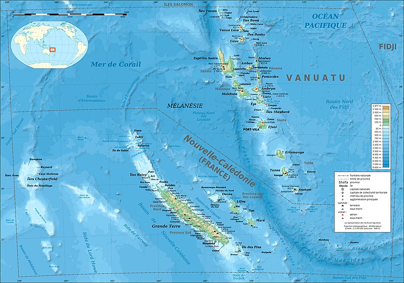
| 17 toleaksat 2009 à 03:12 |  | 2980 × 2090 (1,39 Mio) | Sting | == Summary == {{Location|18|30|00|S|166|00|00|E|scale:10000000}} <br/> {{Information |Description={{en|Bathymetric and topographic map of New Caledonia and Vanuatu, Oceania.}} {{fr|Carte bathymétrique |
Favera va iyeltak
Valevefa bugluyaxa va bat iyeltak :
Jadifa iyeltakura
Valevefi wiki va bat iyeltak malsaved :
- Favera dene azb.wikipedia.org
- Favera dene bg.wikipedia.org
- Favera dene bi.wikipedia.org
- Favera dene bs.wikinews.org
- Favera dene en.wikipedia.org
- Favera dene eo.wikipedia.org
- Favera dene es.wikipedia.org
- Favera dene fi.wikipedia.org
- Favera dene fr.wikipedia.org
- Vanuatu
- Liste des colonies françaises
- Christian Zuber
- Nouvelle-Calédonie
- Référendum en France
- Projet:Cartographie/Cartes standards/Pays
- 2010 par pays en Océanie
- 2011 par pays en Océanie
- Rallye de Nouvelle-Calédonie
- Français océanien
- Utilisateur:Exp JC/Brouillon
- Environnement en Nouvelle-Calédonie
- 2010 en Nouvelle-Calédonie
- 2011 au Vanuatu
- 2010 au Vanuatu
- Favera dene fr.wikinews.org
- Favera dene fr.wikiversity.org
- Favera dene gcr.wikipedia.org
- Favera dene gl.wikipedia.org
- Favera dene he.wikipedia.org
- Favera dene hu.wikipedia.org
- Favera dene ky.wikipedia.org
- Favera dene la.wikipedia.org
- Favera dene lfn.wikipedia.org
- Favera dene nl.wikipedia.org
- Favera dene nn.wikipedia.org
- Favera dene oc.wikipedia.org
- Favera dene pl.wikipedia.org
- Favera dene pl.wikivoyage.org
- Favera dene pt.wikipedia.org
loa favera va bat iyeltak wil !!