
Iyeltak:Nevado del Ruiz Volcano, Colombia.jpg

Lum ke bata abdiwira : 800 × 526 px. Ar goraks: 320 × 211 px | 640 × 421 px | 1024 × 674 px | 1280 × 842 px | 2560 × 1684 px | 4256 × 2800 px.
Xantaf iyeltak (4256 × 2800 pixel, iyeltakaldo : 7,73 Mio, MIME ord : image/jpeg)
Pimtara
| Pimtara |
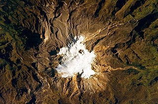
English: In this photo, the volcano’s summit and upper flanks are covered by several glaciers that appear as a white mass surrounding the 1-kilometre-wide Arenas Crater; melt-water from these glaciers has incised the grey to tan ash and pyroclastic flow deposits mantling the lower slopes. A well-defined lava flow is visible at image lower right. This astronaut photograph was taken at approximately 7:45 a.m. local time, when the Sun was still fairly low above the horizon, leading to shadowing to the west of topographic high points. |
| Evla | |
| Klita | NASA Earth Obseravatory |
| Askisik | The NASA Expedition 23 crew |
| Lieu de la prise de vue | | Voir cet endroit et d’autres images sur : OpenStreetMap |
|---|
Cette image ou vidéo a été cataloguée par le Johnson Space Center de la National Aeronautics and Space Administration (NASA) des États-Unis sous Photo ID : ISS023-E-27737.Ce bandeau n’indique rien sur le statut de l’œuvre au regard du droit d'auteur. Un bandeau de droit d’auteur est requis. Voir Commons:À propos des licences pour plus d’informations. Autres langues :
|
Image acquired with a Nikon D3S digital camera fitted with an 800 mm lens, and is provided by the ISS Crew Earth Observations experiment and Image Science & Analysis Laboratory, Johnson Space Center.
Sortara :
| Ce fichier provient de la NASA. Sauf exception, les documents créés par la NASA ne sont pas soumis à copyright. Pour plus d'informations, voir la politique de copyright de la NASA. | ||
 |
Attention :
|
| Annotations | This image is annotated: View the annotations at Commons |
Iyeltakizvot
Witison va iyeltak inde in banugale awir, va evla/bartiv vulegal !!
| Evla/Bartiv | Aluk | Lumeem | Favesik | Sebuks | |
|---|---|---|---|---|---|
| ref | 3 alubeaksat 2010 à 10:10 | | 4256 × 2800 (7,73 Mio) | Originalwana | {{Information |Description={{en|1=In this photo, the volcano’s summit and upper flanks are covered by several glaciers that appear as a white mass surrounding the 1-kilometre-wide Arenas Crater; melt-water from these glac |
Favera va iyeltak
Valevefa bugluyaxa va bat iyeltak :
Jadifa iyeltakura
Valevefi wiki va bat iyeltak malsaved :
- Favera dene ast.wikipedia.org
- Favera dene ca.wikipedia.org
- Favera dene en.wikipedia.org
- Favera dene en.wikiversity.org
- Favera dene es.wikipedia.org
- Favera dene eu.wikipedia.org
- Favera dene fr.wikipedia.org
- Favera dene he.wikipedia.org
- Favera dene id.wikipedia.org
- Favera dene it.wikipedia.org
- Favera dene ka.wikipedia.org
- Favera dene mk.wikipedia.org
- Favera dene nl.wikipedia.org
- Favera dene pt.wikipedia.org
- Favera dene sl.wikipedia.org
- Favera dene sr.wikipedia.org