
Iyeltak:Ligurian Sea map.png
Me rodadin logijaf lum.
Ligurian_Sea_map.png (600 × 505 pixel, iyeltakaldo : 145 kio, MIME ord : image/png)
Pimtara
| Pimtara |
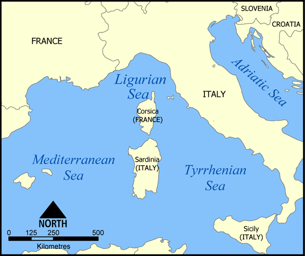
A map showing the location of the Ligurian Sea. Created by NormanEinstein, May 20, 2005. |
| Evla | 20 alubeaksat 2005 (date de téléversement originale) |
| Klita | No machine-readable source provided. Own work assumed (based on copyright claims). |
| Askisik | No machine-readable author provided. NormanEinstein assumed (based on copyright claims). |
| Autres versions |
|

Sortara :
Moi, en tant que détenteur des droits d’auteur sur cette œuvre, je la publie sous les licences suivantes :

|
Permission is granted to copy, distribute and/or modify this document under the terms of the GNU Free Documentation License, Version 1.2 or any later version published by the Free Software Foundation; with no Invariant Sections, no Front-Cover Texts, and no Back-Cover Texts. A copy of the license is included in the section entitled GNU Free Documentation License. |
| Bat iyeltak wetce Creative Commons Attribution-Share Alike 3.0 Unported zo sortayar. | ||
| ||
| Ce bandeau de licence a été ajouté à ce fichier dans le cadre de la procédure de mise à jour des licences des images sous GFDL. |
Va solnarina sorta rorewal
Other versions

|
Une version vectorielle de cette image existe, dans le format « SVG ». Si elle n’est pas inférieure, elle devrait être utilisée à la place de la présente version pour des affichages en plus grandes dimensions ou nécessitant une meilleure résolution.
File:Ligurian Sea map.png → File:Ligurian Sea map hr.svg
Pour plus d’informations sur les images vectorielles, consultez la page de transition de Commons vers le format SVG. Voir aussi les informations à propos de la manière dont le logiciel MediaWiki gère les images au format SVG. |
 |
derivative works
Œuvres dérivées de ce fichier : Ligurian Sea map-bg.png
Iyeltakizvot
Witison va iyeltak inde in banugale awir, va evla/bartiv vulegal !!
| Evla/Bartiv | Aluk | Lumeem | Favesik | Sebuks | |
|---|---|---|---|---|---|
| ref | 20 alubeaksat 2005 à 16:40 | | 600 × 505 (145 kio) | NormanEinstein | A map showing the location of the Ligurian Sea. Created by NormanEinstein, May 20, 2005. {{GFDL-self}} Category:Maps of Seas |
Favera va iyeltak
Valevefa bugluyaxa va bat iyeltak :
Jadifa iyeltakura
Valevefi wiki va bat iyeltak malsaved :
- Favera dene af.wikipedia.org
- Favera dene an.wikipedia.org
- Favera dene ar.wikipedia.org
- Favera dene az.wikipedia.org
- Favera dene az.wiktionary.org
- Favera dene be-tarask.wikipedia.org
- Favera dene be.wikipedia.org
- Favera dene bn.wikipedia.org
- Favera dene bs.wikipedia.org
- Favera dene ca.wikipedia.org
- Favera dene ckb.wikipedia.org
- Favera dene cs.wikipedia.org
- Favera dene da.wikipedia.org
- Favera dene en.wikipedia.org
- Favera dene es.wikipedia.org
- Favera dene fa.wikipedia.org
- Favera dene fi.wikipedia.org
- Favera dene frr.wikipedia.org
- Favera dene fr.wikipedia.org
- Favera dene gl.wikipedia.org
- Favera dene hr.wikipedia.org
- Favera dene ia.wikipedia.org
- Favera dene id.wikipedia.org
- Favera dene ilo.wikipedia.org
- Favera dene is.wikipedia.org
- Favera dene it.wikipedia.org
- Favera dene ja.wikipedia.org
- Favera dene ka.wiktionary.org
- Favera dene ko.wikipedia.org
- Favera dene la.wikipedia.org
- Favera dene lij.wikipedia.org
loa favera va bat iyeltak wil !!