
Iyeltak:Kara Sea map.png
Lum ke bata abdiwira : 658 × 599 px. Ar goraks: 264 × 240 px | 527 × 480 px | 942 × 858 px.
Xantaf iyeltak (942 × 858 pixel, iyeltakaldo : 258 kio, MIME ord : image/png)

|
Cette image (de type locator map) devrait être recréée dans un format vectoriel, en tant que fichier SVG. Cela offrirait plusieurs avantages : voir Commons:Media for cleanup pour plus d'informations. Si une version SVG de cette image est déjà disponible, merci de bien vouloir l'envoyer. Après cela, remplacez ce modèle par {{vector version available|nouveau nom d'image.svg}}.
|
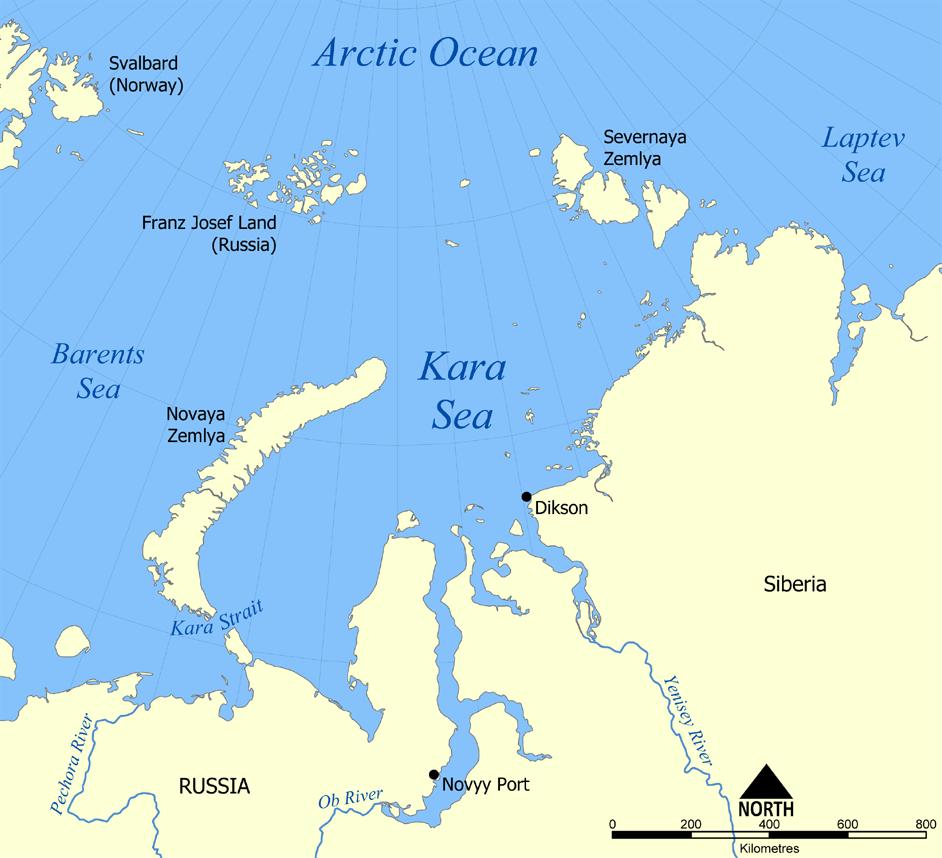
This map shows the location of the Kara Sea north of Russia. The sea is located south of the Arctic Ocean, east of the Barents Sea, west of the Laptev Sea, and is bounded by the Severnaya Zemlya and Novaya Zemlya.
Created by NormanEinstein, November 29, 2005.
Moi, en tant que détenteur des droits d’auteur sur cette œuvre, je la publie sous les licences suivantes :

|
Permission is granted to copy, distribute and/or modify this document under the terms of the GNU Free Documentation License, Version 1.2 or any later version published by the Free Software Foundation; with no Invariant Sections, no Front-Cover Texts, and no Back-Cover Texts. A copy of the license is included in the section entitled GNU Free Documentation License. |
| Bat iyeltak wetce Creative Commons Attribution-Share Alike 3.0 Unported zo sortayar. | ||
| ||
| Ce bandeau de licence a été ajouté à ce fichier dans le cadre de la procédure de mise à jour des licences des images sous GFDL. |
Va solnarina sorta rorewal
derivative works
Derivative works of this file:
Iyeltakizvot
Witison va iyeltak inde in banugale awir, va evla/bartiv vulegal !!
| Evla/Bartiv | Aluk | Lumeem | Favesik | Sebuks | |
|---|---|---|---|---|---|
| ref | 14 pereaksat 2012 à 20:26 | | 942 × 858 (258 kio) | Ras67 | cropped, opt. |
| 29 santaneaksat 2005 à 22:12 |  | 952 × 868 (382 kio) | NormanEinstein | This map shows the location of the Kara Sea north of Russia. The sea is located south of the Arctic Ocean, east of the Barents Sea, west of the Laptev Sea, and is bounded by the Severnaya Zemlya and Novaya Zemlya. Created by NormanEinstein, November 29, |
Favera va iyeltak
Valevefa bugluyaxa va bat iyeltak :
Jadifa iyeltakura
Valevefi wiki va bat iyeltak malsaved :
- Favera dene af.wikipedia.org
- Favera dene an.wikipedia.org
- Favera dene ar.wikipedia.org
- Favera dene azb.wikipedia.org
- Favera dene az.wikipedia.org
- Favera dene bcl.wikipedia.org
- Favera dene be.wikipedia.org
- Favera dene bg.wikipedia.org
- Favera dene bn.wikipedia.org
- Favera dene br.wikipedia.org
- Favera dene bs.wikipedia.org
- Favera dene ca.wikipedia.org
- Favera dene cs.wikipedia.org
- Favera dene cy.wikipedia.org
- Favera dene da.wikipedia.org
- Favera dene de.wikipedia.org
- Favera dene en.wikipedia.org
- Favera dene en.wiktionary.org
- Favera dene eo.wikipedia.org
- Favera dene es.wikipedia.org
- Favera dene eu.wikipedia.org
- Favera dene fa.wikipedia.org
- Favera dene fi.wikipedia.org
- Favera dene frr.wikipedia.org
- Favera dene fr.wikipedia.org
- Favera dene fy.wikipedia.org
loa favera va bat iyeltak wil !!