
Iyeltak:Fiji detail.jpg

Lum ke bata abdiwira : 589 × 600 px. Ar goraks: 236 × 240 px | 600 × 611 px.
Xantaf iyeltak (600 × 611 pixel, iyeltakaldo : 50 kio, MIME ord : image/jpeg)

|
This map has been uploaded by Electionworld from en.wikipedia.org to enable the |
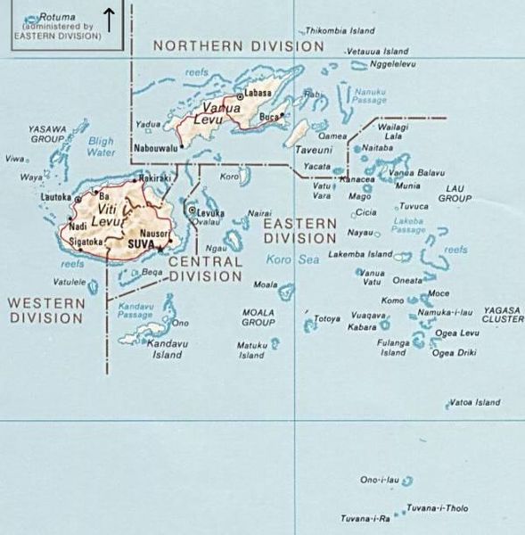
PNG map of Fiji from CIA World Factbook.
Cette image est dans le domaine public parce que son contenu provient du World Factbook, édité par la Central Intelligence Agency des États-Unis d’Amérique.
|
 |
Iyeltakizvot
Witison va iyeltak inde in banugale awir, va evla/bartiv vulegal !!
| Evla/Bartiv | Aluk | Lumeem | Favesik | Sebuks | |
|---|---|---|---|---|---|
| ref | 30 teveaksat 2010 à 12:51 | | 600 × 611 (50 kio) | Telim tor | exchanged positions of Tuvana-i-Ra and Tuvana-i-Tholo (i-Ra is the southwestern one, see also [http://www.un.org/Depts/Cartographic/map/profile/Fiji.pdf this map] (PDF) |
| 27 santaneaksat 2006 à 19:45 |  | 600 × 611 (48 kio) | Electionworld | {{ew|en|Pascal}} PNG map of Fiji from CIA World Factbook. {{PD-USGov-CIA-WF}} Category:Maps of Fiji |
Favera va iyeltak
Valevefa bugluyaxa va bat iyeltak :
Jadifa iyeltakura
Valevefi wiki va bat iyeltak malsaved :
- Favera dene az.wikipedia.org
- Favera dene be.wikipedia.org
- Favera dene cs.wikipedia.org
- Favera dene de.wikipedia.org
- Favera dene en.wikipedia.org
- Favera dene es.wikinews.org
- Favera dene io.wikipedia.org
- Favera dene ka.wikipedia.org
- Favera dene pl.wikipedia.org
- Favera dene ru.wikipedia.org
- Favera dene tr.wikipedia.org
- Favera dene uk.wikipedia.org
- Favera dene www.wikidata.org