
Iyeltak:Carte topographique de Côte d'Ivoire.png
Lum ke bata abdiwira : 586 × 599 px. Ar goraks: 235 × 240 px | 469 × 480 px | 843 × 862 px.
Xantaf iyeltak (843 × 862 pixel, iyeltakaldo : 1,06 Mio, MIME ord : image/png)
| Pimtara |
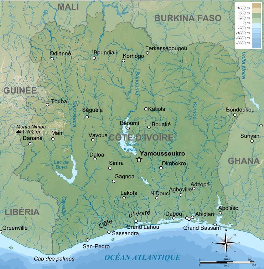
Français : Carte physique de la Côte d'Ivoire. Note : le fond de carte (relief + rivières) est un bitmap (SRTM30 v.2/domaine publique) embarqué dans le svg à l'aide d'Inkscape.
English: Map of Côte d'Ivoire.
Equirectangular projection, WGS84 datum
|
| Evla | |
| Klita |
travail personnel (own work) / png from original svg version Image:Côte d'Ivoire topographic map-fr.svg *Topography : NASA Shuttle Radar Topography Mission (SRTM30 v.2) (public domain) ; *Shoreline and additional data : Demis World Map Data + World data bank II. *Bathymétrie (océan) : Demis World Map Data, vectorisées by Inkscape *Other : Inkscape ; The Gimp |
| Askisik | Bourrichon |
| Autres versions |
|


Moi, en tant que détenteur des droits d’auteur sur cette œuvre, je la publie sous les licences suivantes :

|
Permission is granted to copy, distribute and/or modify this document under the terms of the GNU Free Documentation License, Version 1.2 or any later version published by the Free Software Foundation; with no Invariant Sections, no Front-Cover Texts, and no Back-Cover Texts. A copy of the license is included in the section entitled GNU Free Documentation License. |
Ce fichier est sous licence Creative Commons Attribution – Partage dans les Mêmes Conditions 3.0 (non transposée), 2.5 Générique, 2.0 Générique et 1.0 Générique.
- Til nuyaf :
- Ta walzilira – ta ksudara va kobara azu walzilira azu deara
- Ta warzafa ponara – Ta zalera va grabom
- Nope valevef kredeem :
- gaara – Va folack govanzilil ise va gluyaxa godaful ise gobazel kase betara al zo skud. Laninde gonaskil voxe mekane gometiavel da gelfasik va rin ik rinafa favera vanovar.
- Milinde paká – Ede va bat valdig betal ike artazukar ike voner, pune va nekis valdig wetce mila ok milafa sorta gu bat goxolel.
Va solnarina sorta rorewal
Iyeltakizvot
Witison va iyeltak inde in banugale awir, va evla/bartiv vulegal !!
| Evla/Bartiv | Aluk | Lumeem | Favesik | Sebuks | |
|---|---|---|---|---|---|
| ref | 20 toleaksat 2009 à 15:29 | | 843 × 862 (1,06 Mio) | Bourrichon | {{Information |Description={{en|1=png from original svg version Image:ôte d'Ivoire topographic map-fr.svg}} |Source=travail personnel (own work) |Author=Bourrichon |Date=fév 2009 |Permission= |other_versions= }} {{self2|GFDL|CC- |
Favera va iyeltak
Valevefa bugluyaxa va bat iyeltak :
Jadifa iyeltakura
Valevefi wiki va bat iyeltak malsaved :
- Favera dene br.wikipedia.org
- Favera dene fr.wikipedia.org
- Favera dene lb.wikipedia.org
- Favera dene nl.wikipedia.org
- Favera dene ro.wikipedia.org
- Favera dene ru.wikipedia.org