
Iyeltak:Australia.A2002231.0145.250m NASA Nullarbor.jpg

Xantaf iyeltak (5800 × 4400 pixel, iyeltakaldo : 2,91 Mio, MIME ord : image/jpeg)
Pimtara
- Credit Jacques Descloitres, MODIS Rapid Response Team, NASA/GSFC
http://visibleearth.nasa.gov/view_rec.php?id=4153 archive copy at the Wayback Machine
Metadata Sensor Terra/MODIS Datastart 2002-08-19 Dataend 2002-08-19 Visible Earth v1 ID 21116 Visualization Date 2002-09-16
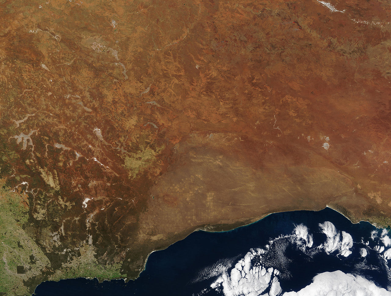
"The striking orange-red colored southern Australian coast contrasts against the deep sapphire-blue waters of the Southern Ocean in this true-color Moderate Resolution Imaging Spectroradiometer (MODIS) image acquired by the Terra satellite on August 19, 2002. In the northern portion of the image, a handful of fires (marked in red) were detected burning in the Great Victoria Desert by the MODIS instrument. South of the desert is the lighter-orange Nullarbor Plain, which stretches for over 1000 kilometers (about 600 miles) from end to end. Finally, just off the coast in the Southern Ocean is the Great Australian Bight, home to Australian Sea Lions, Southern Right Whales, and various fish species."
| Ce fichier provient de la NASA. Sauf exception, les documents créés par la NASA ne sont pas soumis à copyright. Pour plus d'informations, voir la politique de copyright de la NASA. | ||
 |
Attention :
|
en:Image:Australia.A2002231.0145.250m_NASA_Nullarbor.jpg
Sortara :
| Bat iyeltak wetce Creative Commons Attribution-Share Alike 3.0 Unported zo sortayar. Sujet aux avertissements. | ||
| ||
| Ce bandeau de licence a été ajouté à ce fichier dans le cadre de la procédure de mise à jour des licences des images sous GFDL. |

|
Permission is granted to copy, distribute and/or modify this document under the terms of the GNU Free Documentation License, Version 1.2 or any later version published by the Free Software Foundation; with no Invariant Sections, no Front-Cover Texts, and no Back-Cover Texts. A copy of the license is included in the section entitled GNU Free Documentation License. Sujet aux avertissements. |
Iyeltakizvot
Witison va iyeltak inde in banugale awir, va evla/bartiv vulegal !!
| Evla/Bartiv | Aluk | Lumeem | Favesik | Sebuks | |
|---|---|---|---|---|---|
| ref | 24 saneaksat 2005 à 20:27 | | 5800 × 4400 (2,91 Mio) | Albinfo | *Credit Jacques Descloitres, MODIS Rapid Response Team, NASA/GSFC http://visibleearth.nasa.gov/view_rec.php?id=4153 Metadata Sensor Terra/MODIS Datastart 2002-08-19 Dataend 2002-08-19 Visible Earth v1 ID 21116 Visualization Date 2002-09-16 "The |
Favera va iyeltak
Valevefa bugluyaxa va bat iyeltak :
Jadifa iyeltakura
Valevefi wiki va bat iyeltak malsaved :
- Favera dene af.wikipedia.org
- Favera dene an.wikipedia.org
- Favera dene ar.wikipedia.org
- Favera dene arz.wikipedia.org
- Favera dene ast.wikipedia.org
- Favera dene az.wikipedia.org
- Favera dene ba.wikipedia.org
- Favera dene be-tarask.wikipedia.org
- Favera dene be.wikipedia.org
- Favera dene bg.wikipedia.org
- Favera dene bn.wikipedia.org
- Favera dene ca.wikipedia.org
- Favera dene ceb.wikipedia.org
- Favera dene cy.wikipedia.org
- Favera dene da.wikipedia.org
- Favera dene de.wikipedia.org
- Favera dene en.wikipedia.org
- Favera dene en.wikiversity.org
- Favera dene en.wikivoyage.org
- Favera dene eo.wikipedia.org
- Favera dene es.wikipedia.org
- Favera dene es.wikivoyage.org
- Favera dene eu.wikipedia.org
- Favera dene fa.wikipedia.org
- Favera dene fi.wikipedia.org
- Favera dene frr.wikipedia.org
- Favera dene fr.wikipedia.org
loa favera va bat iyeltak wil !!