Iyeltak:1658 Jansson Map of the Indian Ocean (Erythrean Sea) in Antiquity - Geographicus - ErythraeanSea-jansson-1658.jpg

Le contenu de la page n’est pas pris en charge dans d’autres langues.
Teliz mal Wikipedia.

Xantaf iyeltak(5000 × 4194 pixel, iyeltakaldo : 6,03 Mio, MIME ord : image/jpeg)

Bat iyeltak tir mal Wikimedia Commons ise gan yonar abdumimaks rotir zo faver. Pimtara moe inafu iyeltakbu valeveon zo nedir.

Johannes Janssonius : Erythraei Sive Rubri Maris Periplus.   (Wikidata search (Cirrus search) Wikidata query (SPARQL)  Create new Wikidata item based on this file)
Artiste
Johannes Janssonius  (1588–1664)  wikidata:Q949492 s:it:Autore:Johannes Janssonius
 
Autres noms
Jan Jansson, Jan Jansz, Jan Janszoon, Joannes Janssonius
Description cartographe, éditeur ou éditrice is marchand d'estampes néerlandais
Date de naissance / décès 1588 Éditer sur Wikidata 11 pereaksat 1664 / 1664 Éditer sur Wikidata
Lieu de naissance / décès Arnhem Amsterdam
Période d’activité de 1616 à 1664
date QS:P,+1650-00-00T00:00:00Z/7,P580,+1616-00-00T00:00:00Z/9,P582,+1664-00-00T00:00:00Z/9
Lieu de travail
Amsterdam (1612–1664); Arnhem (1612–1612) Éditer sur Wikidata
Autorité
artist QS:P170,Q949492
Titre
Erythraei Sive Rubri Maris Periplus.
Pimtara
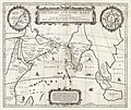
English: An unusual and attractive 1658 map of the Indian Ocean, or Erythraean Sea, as it was in antiquity. Composed by Jan Jansson after a similar 1597 map published by A. Ortelius in his Parergon . Covers from Egypt and the Nile valley eastward past Arabia and India, to Southeast Asia and Java. Cartographically, India, Arabia, and Africa roughly correspond to the conventions of the period. Southeast Asia is less recognizable, but the Malay Peninsula, Sumatra, and Java are clearly noted. Most of the place names used throughout are derived from Ptolemy, who himself based his description of the region heavily on records from Alexander the Great's conquests. Two smaller maps in the upper left and right quadrants are of exceptional interest. The upper left chart shows northwestern Africa and is titled Annonis Periplus. This is a reference to the legendary expeditions of the Carthaginian King Hanno, said to have been the first to access the Indian Ocean by sailing around the southern tip of Africa. Incidentally, en route, he is also said to have been the first to tame a lion. The upper right chart shows the northern polar regions as they were perceived at the time. A landmass covering the polar ice cap is indentified as Hyperborea. To the left of this, roughly where North America rests today, the island of Atlantis appears; while Scythia, Europe (Thule) and Asia are on the right. Greenland and possibly Iceland appear at the bottom. This map is intended to point out the possibility of a Northeast Passage to Asia, which was at the time being actively sought after by Dutch, English, and Russian navigators. Both smaller maps, the primary title area at top center, and an Latin explanation for the map at bottom center, are surrounded by baroque strapwork style borders. This remarkable map was published in volume six, the Orbis Antiquus , of Jan Jansson's Novus Atlas .
Evla 1658 (undated)
Dimensions hauteur : 16 pouces (40,6 см) ; largeur : 19 pouces (48,2 см)
dimensions QS:P2048,16U218593
dimensions QS:P2049,19U218593
Numéro d’inventaire
liens Geographicus : ErythraeanSea-jansson-1658
Source / photographe

Jansson, J., Novus Atlas, Sive Theatrum Orbis Terrarum: In quo Orbis Antiquus, Seu Geographia Vetus, Sacra & Profana exhibetur, Volume 6, 1658.

Novera
(Va bata ewava gin faver)
Ceci est une reproduction photographique fidèle d'une œuvre d'art originale en deux dimensions. L'œuvre d'art elle-même est dans le domaine public pour la raison suivante :
Public domain

Cette œuvre est également dans le domaine public dans tous les pays pour lesquels le droit d’auteur a une durée de vie de 100 ans ou moins après la mort de l’auteur.


Vous devez aussi inclure un modèle indiquant pourquoi cette œuvre est dans le domaine public aux États-Unis.
La position officielle de la Fondation Wikimedia est que « les représentations fidèles des œuvres d'art du domaine public en deux dimensions sont dans le domaine public et les exigences contraires sont une attaque contre le concept même de domaine public ». Pour plus de détails, voir Commons:Quand utiliser le bandeau PD-Art.
Cette reproduction photographique est donc également considérée comme étant élevée dans le domaine public. Merci de noter qu'en fonction des lois locales, la réutilisation de ce contenu peut être interdite ou restreinte dans votre juridiction. Voyez Commons:Reuse of PD-Art photographs.

Légendes

Ajoutez en une ligne la description de ce que représente ce fichier

Éléments décrits dans ce fichier

dépeint français

collection français

Geographicus français

type MIME français

image/jpeg

cad73cb9d07e5064c0b7cbc491e54f6d6b0b9261

méthode de détermination français : SHA-1 français

6 324 965 octet

hauteur français

4194 pixel

largeur français

5000 pixel

Iyeltakizvot

Witison va iyeltak inde in banugale awir, va evla/bartiv vulegal !!

Evla/BartivAlukLumeemFavesikSebuks
ref23 bareaksat 2011 à 20:58Aluk va siatos ke 23 bareaksat 2011 à 20:585000 × 4194 (6,03 Mio)BotMultichillT{{subst:User:Multichill/Geographicus |link=http://www.geographicus.com/P/AntiqueMap/ErythraeanSea-jansson-1658 |product_name=1658 Jansson Map of the Indian Ocean (Erythrean Sea) in Antiquity |map_title=Erythraei Sive Rubri Maris Periplus. |description=An

Valevefa bugluyaxa va bat iyeltak :

Jadifa iyeltakura

Valevefi wiki va bat iyeltak malsaved :