
Iyeltak:Vredefort.jpg

Lum ke bata abdiwira : 800 × 600 px. Ar goraks: 320 × 240 px | 640 × 480 px | 1024 × 768 px.
Xantaf iyeltak (1024 × 768 pixel, iyeltakaldo : 266 kio, MIME ord : image/jpeg)
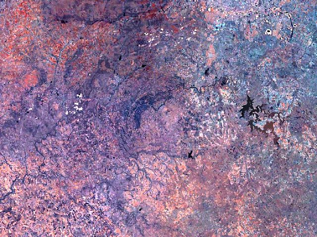
| Pimtara | Vredefort crater has a diameter of 300 km, and its circular structure nearly fills the complete image. The Vredefort dome, a conspicuous geologic feature about 50 km in diameter, stands out at the center. |
| Klita | Created with NASA WorldWind by User:Vesta using Landsat 7 (Visible Color) satellite image. |
| Askisik | User:Vesta |
27°0′0″S 27°30′0″E / 27°S 27.5°E
| Cette image est dans le domaine public car elle est constituée d'une capture d'écran du logiciel World Wind de la NASA qui utilise des données du domaine public, comme Blue Marble, MODIS, Landsat, SRTM, USGS ou GLOBE.
|
 |
Iyeltakizvot
Witison va iyeltak inde in banugale awir, va evla/bartiv vulegal !!
| Evla/Bartiv | Aluk | Lumeem | Favesik | Sebuks | |
|---|---|---|---|---|---|
| ref | 7 taneaksat 2006 à 09:12 | | 1024 × 768 (266 kio) | Vesta~commonswiki | * '''Description:''' Vredefort crater has a diameter of 300 km, and its circular structure nearly fills the complete image. The Vredefort ring, a conspicuous feature, 50 km in diameter, stands out at the center. *'''Source:''' Created with NASA WorldWind |
Favera va iyeltak
Valevefa bugluyaxa va bat iyeltak :
Jadifa iyeltakura
Valevefi wiki va bat iyeltak malsaved :
- Favera dene be.wikipedia.org
- Favera dene de.wikipedia.org
- Favera dene de.wikivoyage.org
- Favera dene es.wikipedia.org
- Favera dene hr.wikipedia.org
- Favera dene hy.wikipedia.org
- Favera dene it.wikipedia.org
- Favera dene lt.wikipedia.org
- Favera dene ml.wikipedia.org
- Favera dene pt.wikipedia.org
- Favera dene ru.wikipedia.org
- Favera dene sh.wikipedia.org
- Favera dene sv.wikipedia.org