
Iyeltak:StLuciaWetland L7 07may01.jpg
Me rodadin logijaf lum.
StLuciaWetland_L7_07may01.jpg (540 × 540 pixel, iyeltakaldo : 102 kio, MIME ord : image/jpeg)
Pimtara
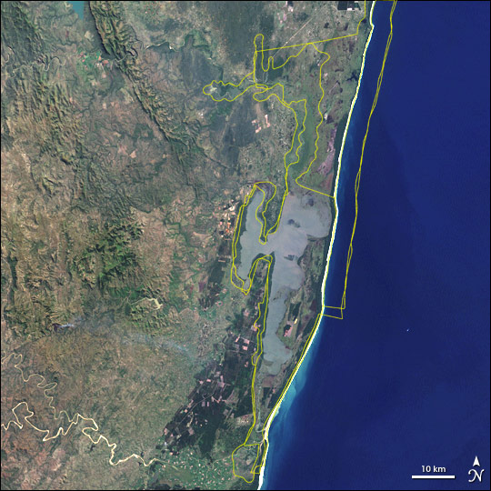
| Pimtara | Satellite image of w:Greater St. Lucia Wetland Park, South Africa. Borders of the various conservation areas in the park are outlined in yellow. |
| Evla | |
| Klita | http://earthobservatory.nasa.gov/Newsroom/NewImages/images.php3?img_id=16722 |
| Askisik | Jesse Allen, NASA Earth Observatory, using Landsat and GIS data obtained from the University of Maryland’s Global Land Cover Facility. |
| Novera (Va bata ewava gin faver) |
Public domain |
| Autres versions | Larger, uncropped version available from source URL (sans borders). |
Sortara :
| Ce fichier provient de la NASA. Sauf exception, les documents créés par la NASA ne sont pas soumis à copyright. Pour plus d'informations, voir la politique de copyright de la NASA. | ||
 |
Attention :
|
Iyeltakizvot
Witison va iyeltak inde in banugale awir, va evla/bartiv vulegal !!
| Evla/Bartiv | Aluk | Lumeem | Favesik | Sebuks | |
|---|---|---|---|---|---|
| ref | 19 alubeaksat 2006 à 16:10 | | 540 × 540 (102 kio) | Holly Cheng | {{Information | Description=Satellite image of w:Greater St. Lucia Wetland Park, South Africa. Borders of the various conservation areas in the park are outlined in yellow. | Source=http://earthobservatory.nasa.gov/Newsroom/NewImages/images.php3?img_i |
Favera va iyeltak
Valevefa bugluyaxa va bat iyeltak :
Jadifa iyeltakura
Valevefi wiki va bat iyeltak malsaved :
- Favera dene af.wikipedia.org
- Favera dene ar.wikipedia.org
- Favera dene ast.wikipedia.org
- Favera dene az.wikipedia.org
- Favera dene be.wikipedia.org
- Favera dene ca.wikipedia.org
- Favera dene cs.wikipedia.org
- Favera dene cv.wikipedia.org
- Favera dene cy.wikipedia.org
- Favera dene de.wikipedia.org
- Favera dene de.wikivoyage.org
- Favera dene en.wikipedia.org
- Favera dene eo.wikipedia.org
- Favera dene es.wikipedia.org
- Favera dene fi.wikipedia.org
- Favera dene fr.wikipedia.org
- Favera dene fr.wikivoyage.org
- Favera dene gl.wikipedia.org
- Favera dene he.wikipedia.org
- Favera dene hr.wikipedia.org
- Favera dene hu.wikipedia.org
- Favera dene hy.wikipedia.org
- Favera dene is.wikipedia.org
- Favera dene it.wikipedia.org
- Favera dene ja.wikipedia.org
- Favera dene ka.wikipedia.org
- Favera dene lv.wikipedia.org
- Favera dene mt.wikipedia.org
- Favera dene no.wikipedia.org
- Favera dene oc.wikipedia.org
- Favera dene pl.wikipedia.org
- Favera dene ru.wikipedia.org
- Favera dene sh.wikipedia.org
- Favera dene sk.wikipedia.org
- Favera dene sr.wikipedia.org
- Favera dene uk.wikipedia.org
- Favera dene vec.wikipedia.org
- Favera dene vi.wikipedia.org
loa favera va bat iyeltak wil !!